Showing posts with label I. giganticaerulea. Show all posts

Monday, October 25, 2021

Hurricane Ida Plows Through the Center of S.E. Louisiana Iris Territory

By Gary Salathe

In my May 17th World of Irises posting, I wrote about the iris bloom at projects that the Louisiana Iris Conservation Initiative (LICI) had completed for the 2020–2021 fall and winter Louisiana iris planting season. We had very good bloom even though some of the locations experienced what we thought were tough conditions from Hurricane Zeta.

Hurricane Zeta hit southeast Louisiana on October 28, 2020. The day before it made landfall, its intensity rapidly ramped up from tropical storm to a Category 3 hurricane. The storm moved quickly through the area, reducing the height of its storm-surge tides and making damage in southern Louisiana less widespread. However, the intense damage caused by the storm in areas just east of New Orleans caught everyone by surprise.

LICI’s main function is to relocate Louisiana irises threatened with destruction to safer areas where the public can see them growing and blooming in their native habitat. The best locations have raised boardwalks that allow the public to walk above a swamp or marsh to safely experience the habitat. These are typically in area wildlife refuges and public nature parks.

The damage caused by Hurricane Zeta to our iris plantings at the boardwalks was very minimal, except for one location that was directly in the path of the hurricane eye-wall. We figured, “Well, you only get a direct hit from a strong hurricane once every few years, so we are likely good for a while before another one comes along.” WRONG!

On August 29, 2021, 16 years to the day that Hurricane Katrina came close to wiping southeast Louisiana off of the map with 28-foot high storm-surge tides, Hurricane Ida made its appearance in our area. While Hurricane Zeta and Katrina stayed on a track to the east of New Orleans, Hurricane Ida’s center traveled to the west of New Orleans. This put the stronger south and southeasterly winds that are found on the east side of any hurricane directly over iris country in southeast Louisiana.


Louisiana iris distribution and recent hurricanes in Southeastern Louisiana: Hurricane Ida's path is shown in red. The winds on the right side of every hurricane blow from the south and then the east as the storm approaches. This map shows why the high storm-surge tide was so destructive compared to other storms to a huge area of marsh and swamp that is home to the Louisiana iris species I. giganticaerulea (shown in blue). The city of New Orleans is on the south side of Lake Pontchartrain.

The reports have been slowly coming in on the damage to the boardwalks and irises in our projects. It seems that even though the damage to the irises has been far worse than from Hurricane Zeta, none of the stands of irises in these projects have been totally wiped out, as the photos below show. However, at the Town of Jean Lafitte boardwalk, which likely experienced the worst damage, we still aren’t sure if there are many irises left. In this location, irises are mixed in with tall grasses in the swamp away from the boardwalk, so the irises are hard to see.


The town of Jean Lafitte elevated boardwalk before and after volunteers from LICI and Common Ground Relief cleared off the storm debris.


Although all of this sounds like we are optimistic about the impact on the irises in our projects, we are not optimistic for the irises in the entire area of southeast Louisiana. Tens of thousands of the I.giganticaerulea species of Louisiana iris growing on floating land south of New Orleans were likely destroyed when Hurricane Ida carved off huge chunks that floated out into open salt water. The result is that we have likely just lived through an event here that has done more catastrophic damage to the wild irises of southeast Louisiana in one day than any other event that has happened in the last sixty years.


These before and after photos show just one area of floating land, called flotant, that was broken free because of Hurricane Ida's winds and floated away. It is likely that there were large stands of I. giganticaerulea growing in the flotant.


This photo shows an area of flotant that has broken free and was seen floating out into the open waters of Barataria Bay. It had been established for so long that trees had rooted in and grown on it.


The eye of Hurricane Ida passed directly over the town of Lockport's elevated boardwalk, which is the site of one of LICI's restoration projects. LICI's local volunteer, Mike Glaspell, headed up the effort to clean off and repair the boardwalk. The irises survived the storm and are doing well.


The irises in our Big Branch National Wildlife Refuge project have survived the hurricane, but are struggling with a naturally occurring fungus called "rust". The picture on the right was taken in April.


The Northlake Nature Center had significant damage to their stands of old growth hardwood trees. The high water from this year's rains has threatened the irises. Hurricane Ida's heavy rain arrived just as the water level in the swamp was finally coming down. 
The picture on the right was taken in April.


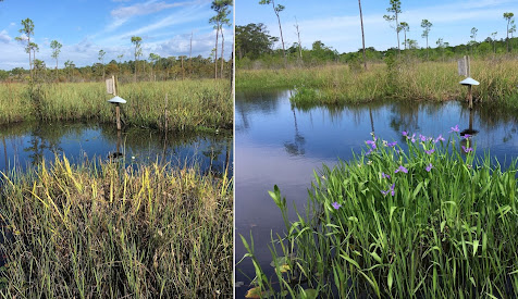
The irises in our Bayou Sauvage National Wildlife Refuge project have survived the hurricane, but are struggling after dealing with high water from the heavy rains this year. The water level was finally dropping when the rains from Hurricane Ida raised it up again. The picture on the right was taken in April.


The area shown above is part of a LICI iris restoration project in Fontainebleau State Park. It was totally submerged by 3 feet of water from the storm-surge tide of Hurricane Ida. Being under water actually protected the irises from the wind and waves. All of the irises appear to have survived. The picture on the right was taken in April.


Hurricane Ida's high tides impacted the Joyce Wildlife Refuge boardwalk, a location for one of our most successful iris restoration projects. Most of the irises that were growing in the semi-liquid swamp muck have disappeared. We are hopeful that they were just pushed further back into the swamp and will reestablish themselves there. The irises that were growing on the flotant did well. They likely floated up with the storm-surge and settled back down intact once the tide went out. The photo on the left was taken in April. The same area is shown on the right one week after the storm. A recent visitor to the boardwalk told us the irises are starting to peek up from under the debris at that spot.


There are still a few areas where we have projects that we have not been able to visit yet due to their still needing to be cleared of debris. Like everyone else in southeast Louisiana, we will pick ourselves up and carry on with our work. We are all motivated by our love for Louisiana and a desire to do our small part in preserving the plants and habitat that makes this state so special.


The Louisiana Iris Conservation Initiative website can be found here: https://www.licisaveirises.com/

Recent articles about our work can be found here: https://www.licisaveirises.com/news

Our Facebook page can be found here: https://www.facebook.com/licisaveirises/

Our email address is: licisaveirises@gmail.com


Monday, July 26, 2021

Blooming Irises, The Last Reminder of a Village That Was

By Gary Salathe

A project of the Louisiana Iris Conservation Initiative (LICI) now has an important historical aspect to it. 

Here's the backstory:

The Battle of New Orleans took place on January 8, 1815 and was the last event in the War of 1812 between the British and the new American nation. The battle between the professional British army and the rag-tag, thrown together, US military force resulted in a victory for the young United States over what was then a world power.

The Battle of New Orleans took place on January 8, 1815. Unbeknownst to the participants of the battle, a treaty had been signed 18 days before by the United States and Britain, ending the war of 1812.  

In 1855 plans were made to build a monument near the location of the earthworks that the Americans, led by Andrew Jackson, stood behind to successfully repulse the British. It was not completed until the land was transferred to the federal government in 1907 because funding was in short supply.

In 1864 the Union Army established a cemetery to bury Civil War casualties near the site of the famous battleground. Over the years, soldiers from nearly all of America’s wars have been buried in this hallowed ground; now called the Chalmette National Cemetery.

On August 10, 1939, Congress established Chalmette Battlefield as a National Historical Park. The two historic parcels of property have been separated from one another since the early 1800’s by a tract of land that was purchased by Pierre Fazende, a “free man of color.” In 1856 Pierre turned the land over to his son who divided the property into 33 lots and sold them to other free people of color. After the Civil War, some lots were sold to freed slaves, which would have given them ownership of property for the first time.  

A recent painting of what the village of Fazendeville would have 
looked like in its prime.  

As time passed, a one-room school house, Baptist church, dance hall, grocery store and two barrooms appeared along the single street and it slowly developed into a village. The village became known as Fazendeville, and was home to thirty families living in thirty homes.  Life in Fazendeville remained tranquil and undisturbed for more than 100 years.  However, a chain of events began, beyond the control of the families, that would forever change their lives.

In 1962, civic boosters in the area began efforts to unite the Chalmette Battlefield with the Chalmette National Cemetery. This involved taking possession of the field that laid between the two, which was the land that British soldiers marched across in their attack on the American lines.  They wanted to create one large tract of land for the Chalmette National Historic Park. The timing was to coincide with the sesquicentennial of the Battle of New Orleans on its 150th anniversary in 1965. There was only one problem: homes and buildings of Fazendeville sat on land separating the battlefield from the cemetery.

The village of Fazendeville was located right in the middle of the 
historic Chalmette Battlefield.

 
The residents of Fazendeville were soon overwhelmed by the drive to combine these federal properties. In the “Can Do” age of the 1950’s and 1960’s huge public works projects across the country moved forward using the accepted wisdom that whole communities being displaced isn't enough of a reason to stop progress. A legal process to expropriate property from Fazendeville residents began.
 

 Fazendeville

At the time, a typical new home in the area appraised for $16,500. Residents of Fazendeville were paid $6,000 for their older homes, making it financially impossible for many to find a home to replace the one they lost. 


Some of the buildings in Fazendeville are shown in this photo. It was taken as planning was underway to expropriate the properties.

In early 1965, the last building in Fazendeville was bulldozed and debris hauled off. Within a year the ground was scraped clear so that only a slight indention of the old roadbed could be seen... if you looked very carefully.


The photo shows the 1965 sesquicentennial event for the battlefield as it was underway. 


Fast-forward to 2020: 


Until the 1930’s, Chalmette Battlefield was bordered by a cypress swamp on the North with the river batture (wetland) along the Mississippi River on the South. The site is in St. Bernard Parish where Louisiana irises grew in vast numbers within its swamps and marshes throughout history. Because of this, the US Park Service approved a Louisiana Iris Conservation Initiative (LICI) proposed planting of native Louisiana irises in a bog located along the south side of the battlefield. Due to rigorous criteria used to approve proposed projects on US National Park Service property, this was only the second permit issued at the battlefield in the last ten years. It was approved in part because staff at the park thought there were no irises growing on the property.


This is what I found when I walked out into the field for the first time in February, 2021.


On February 10, 2021, almost a year after the iris planting project was proposed, I was one of four volunteers that planted the first batch of test irises.  When we were finished, I noticed a clump of what looked like Louisiana irises growing out in the field across the road from where we were working. A few days later I received permission to walk the field and discovered multiple patches of Louisiana irises that included anywhere from one hundred to multiple hundreds of irises in each. I assumed these were wild, light blue I. giganticaerulea. This species of Louisiana iris is native to the area, and I thought they may have been overlooked by the park staff because the largest patches were a long way from the road. This field is never cut in March or April, so there would be no reason for any of the park staff to be out in the field at the time these irises would be in bloom.

We made plans to walk the field during bloom season and gathered up a group of LICI’s supporters and some of the park staff. They had become very interested in the mysteriousness of Louisiana irises growing in the middle of the battlefield. Interest peaked further because the irises appeared to have been growing there for many years, if not decades.


Friends of LICI and staff of the US Park Service find the first patch of blooming Louisiana irises on the trip out into the field on March 29th.  We estimated that there were a total of a few thousand Louisiana irises if all of the patches of irises were combined.


On March 29th the group assembled in a small parking area on the paved road and started walking into the field. We quickly discovered that the irises were not light blue I. giganticaerulea, but were lavender-purple. These irises were most likely I. vinicolor which results from the first cross of two types of Louisiana irises: I. giganticaerulea and I. fulva.  Every iris spread out over a long and narrow section of the field was the same-colored iris, with some slight variations in color found in just a few clumps.


I. vinicolor are shown in one of the iris patches on the Chalmette Battlefield.  
(Photo by Paul Christiansen)

Then the group ran across a few clumps of plants in bloom that made us all stop in our tracks. It was a non-native plant, originally from Africa, called the crinum lily. Seeds of the crinum lily are known to have been brought to the Americas by slaves. It’s been grown in gardens of some African Americans since then, passed down from one generation to another, as a reminder of their heritage.


Some of the crinum lilies are seen blooming on the edge of one of  the patches of irises. 

(Photo by Paul Christiansen)

We then located the faint outline of the old  Fazendeville roadbed. By following the roadbed through the field, we figured out that all of the irises and crinum lilies were growing on only one side of the road, the side where the houses of Fazendeville residents once stood. The clumps of irises also ended about where their rear lot line would have been. 

We all stood there thinking the same thought; we had likely found the remnants and offspring of two species of plants that once grew in the gardens surrounding the homes in Fazendeville. Somehow, the plants survived when the homes were moved or torn down in the 1960’s and are now spreading out in the field right in the middle of the Chalmette Battlefield. It was an emotional moment for many of us. We found a silent reminder of the town and people that once lived in this place. For an iris person, these are emotions you never thought that you'd have as part of your hobby.


One of only three small clumps of irises that were a little off  colored from the others.  They appeared to have more of the red I. fulva color.

It makes sense that I. vinicolor would have been irises of choice for people in Fazendeville to grow. During the first half of the 20th century, there may have been tens of thousands light blue colored I. giganticaerulea irises blooming along the roads in Chalmette and the red I. fulva along the Mississippi River batture nearby. People would have collected the harder-to-find wine colored I. vinicolor iris to plant in their gardens. Fazendeville was located in a section of Chalmette where the distance separating the cypress swamps to the north holding the I. giganticaerulea iris and the Mississippi River batture holding I. fulva is the narrowest. There were likely I. vinicolor irises growing in the area as a result of natural cross-pollination between the two species.


We are excited that what started off as a simple iris restoration project now has important historical significance. Plans are underway for LICI volunteers and the staff of the park to move some of the irises and crinum lilies to a location near the parking area with a written display installed to create a living memorial to the residents of Fazendeville.

The Louisiana Iris Conservation Initiative website can be found here: https://www.licisaveirises.com/

Recent articles about our work can be found here: https://www.licisaveirises.com/news

Our Facebook page can be found here:  https://www.facebook.com/licisaveirises/

Our email address is: licisaveirises@gmail.com